 Program Functions and Features Program Functions and Features

|
|
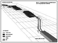
 3D Geological Modeling 3D Geological Modeling |
|
LYNX Geological modeling is based on proven surface and volume modeling
technology allowing 3D interpretation and
modeling of complex geological structures. The geological modeling functions
are fully integrated with LYNX hole data, data
analysis, geostatistical estimation and engineering applications.
 3D interactive geological interpretation 3D interactive geological interpretation
|
|
- Background displays of any combination of data structures in a wide range
of display formats
- Interactive 3D interpretation of volume boundaries into complex irregular
shapes
- Interactive geological sectioning at any view plane orientation through
defined geological units.
Surface- based modeling tools provide an alternative modeling option to
interactive interpretation. They allow rapid generation of geological models
from structural and stratigraphic surface information. Surface-based techniques
are particularly appropriate to relatively simple geological conditions,
such as layered stratigraphy. |
 |
3D visualization and interpretation
|
|
Proven volume modeling technology and interactive view plane manipulation
capabilities allow complex geological conditions to be interpreted using
methods that are familiar to all geologists. Interpretation progresses
from sections, to intersecting fence sections, to a fill 3D interpretation
of geological volumes. Any degree of subsurface complexity may be modeled.
Interpretation may be made at any orientation on 2D sections or in a full
3D modeling environment. |
 |
3D Geological modeling from surfaces
|
|
Functionalities
- Map data manipulation tools, for contouring, thinning, clipping, intersection and coordinate transformation
- TIN surface modeling for the triangulation of surface, with feature-honoring tools
- Surface manipulation of multiple TIN surfaces for generation of structural and stratigraphic
modeling information
- Surface clipping / truncation between TIN surfaces to handle outcrop, erosion and pinchout conditions
- Structural surface modeling for representation of topography, fault surfaces and geological contacts
- Stratigraphic modeling of variable thickness units by auto-generation of volume elements between
TIN surfaces
|
 |
3D interpretation and visualization provides presentation-quality perspective views for all LYNX data structures.
Manipulation tools include interactive rotation, panning, zooming, scaling,
color-map definition and data selection. Editing and interpretation in
a full 3D modeling environment are available to the user. |
|
Page Top 
|
|
3D Geostatistics and Estimation |
|
The LYNX geostatistical analysis and estimation applications are a windows
based implementation of GSLIB 3D geostatistics.
LYNX also includes Direct Volume Estimation for the estimation of complex
volumes, eliminating the need for a
3D grid and grid sub-blocking.
Data Functions and Compositing
|
|
- Arithmetic, log or trip functions of project variables
- Logical functions of characteristics and/or variables
- Compositing of hole data samples
- Intersection of hole / geology to assign geological model characteristics
to hole data structures
|
 |
Geostatistical Analysis
|
|
- Data transformation capabilities, including log, indicator, rank order and normal scores transforms.
- Semi-variogram analysis of the spatial variability of project variables,
including 3D trend surfaces.
- Semi-variogram models include nested spherical, gaussian, exponential and power models in any
combination.
|
|
Estimation capabilities include a range of kriging options and semi-variogram
model types, and all necessary facilities for dealing with variable sample
density, anisotropy, non-normal distributions and underlying spatial trends.
These ensure that the estimation process can deal with cases of complex
spatial variability.
3D grid manipulation capabilities provide a means of combining estimated
variable values using complex arithmetic or logical functions. 3D grid
import / export facilities provide the options of using external prediction
facilities where appropriate, and of exporting grid data structures for
external analysis.
Direct volume estimation provides a unique method for estimating variables
directly into complex volumes eliminating the need for a 3D grids or sub-blocking.
Hole data functions allow generation of variable and characteristic functions
that are tailored to the project.
Sample compositing for regularization of samples in hole data structures,
including the honouring of geological intersections. |
Statistical Analysis
|
|
- Univariate statistics including mean, sample size, standard error, histogram,
probability, correlation, etc.
|
 |
Geostatistical Estimation
|
|
- 3D kriging estimation of variable values using normal or universal kriging and point or volume
kriging algorithms.
- 3D inverse distance interpolation of variables for instances when kriging prediction is inappropriate.
- Geological control of sample and grid cell selection for prediction of geologically influenced
variables.
- Spatial data control of sample selection by octant search.
- 3D grid manipulation allows combination of estimated values using a wide variety of functions.
- Direct volume estimation for kriging into irregular volumes.
|
The geostatistical analysis toolkit includes facilities for identifying
and isolating geological influences, directional influences due to anisotropy,
and underlying data trends. A range of data transformation options extends
the analytical capabilities to deal with cases of non-normal value distribution.
All facilities and results are accessible through an interactive, point-and-click
graphics interface. |
|
Page Top
|
|
Underground Mine Design & Planning |
|
LYNX Underground Engineering provides a 3D platform for interactive design
and layout of underground workings.
A range of design, layout and survey control options facilitate the creation,
management and maintenance of complex excavation geometries for a wide
variety of deposits, mining methods and design conditions.
Interactive 3-D layout tools
|
|
- Background display for any combination of geological, geostatistical, excavation, mine development,
or database information
- Interactive definition of excavation boundaries and assignment of engineering parameters for
planning
- Assembly tools for replicating and positioning standard excavation units
- 3D perspective views in any orientation to assist in rapid visual appreciation of the spatial
relationships of mine geometry
- Analysis tools such as an interactive analyze option for instant quick views of volumes
and reserves during the design process
|
 |
Survey volumes
|
|
Mine models representing “as mined” volumes based on surveyed excavation
limits is the basis to excavation control, reconciliation of production,
and means to an effective grade control process. |
Grade control
|
|
- Use of in-situ sample information.
- Grade entry via digitizer or direct file transfer.
- Analysis of grade variance and distribution.
- Direct Volume Estimation of production workings.
|
 |
Mine development design tools
|
|
- Ramp and development design with variable grade, elevation and profiles along centerlines
- Geometric design tools such as curve, straight line and vertical functions
- Profile definition for rectangular, arched and circular excavation profiles
|
 |
|
|
Page Top
|
|
Geo-Engineering Design |
|
LYNX geo-engineering design provides a 3D geoscience platform for interactive
design, planning and construction control of surface and underground excavations
and other engineering structures such as dams, waste or turbine rooms.
It includes a range of design options that facilitate development of complex
excavation geometries for a wide variety of design conditions.
Interactive 3D design tools
|
|
- Background displays for any combination of hole geological, geostatistical, excavation data
in a wide variety of formats
- Interactive definition of excavation boundaries and assignment of engineering
parameters for planning
- 3-D perspective views in any orientation to assist in rapid visual appreciation of the spatial
relationships of mine geometry
- Interaction sectioning at any view plane, including excavation profiles
|
Lerchs-Grossmann pit optimisation
|
|
3D pit optimization provides a method for generating preliminary open pit
limits based on economic criteria.
Using a 3D grid of net $ values generated from geostatistical models of
relevant grades; taking into account key variables such as recoverable
commodity values, mining and processing costs, haulage costs, depth, metal
recovery and other operating costs. The method optimizes the total net
profit from the mining operation, constrained by wall slopes in different
pit sectors, to obtain the excavation limits, which contain the largest
possible profit. Profit constraints allow definition of staged pits based
on profitability. |
Grade control options
|
|
- Excavation volume reporting of any volume or planning
unit
- Analysis of grade variance & distribution
- Direct volume estimation of production workings
|
 |
Conical expansion design
|
|
- Interactive definition and editing of surface excavations or surface dumps
- Slope and berm control by sector and elevation limits.
- Geological and topographical control of profile projections
- Top-down or bottom-up design to allow excavation or dump/fill design based on surface boundary constraints
|
 |
Strip mine design tools
|
|
- Design of panel, strip or block layouts
- Design of box cuts or special excavation shapes
- Automatic clipping of cut boundaries
|
 |
|
|
Page Top
|
|
Geo-Engineering Design |
|
LYNX geo-engineering design provides a 3D geoscience platform for interactive
design, planning and construction control of surface and underground excavations
and other engineering structures such as dams, waste or turbine rooms.
It includes a range of design options that facilitate development of complex
excavation geometries for a wide variety of design conditions.
Interactive 3D design tools
|
|
- Background displays of any combination of geoscience and/or engineering data structures in
a wide range of display formats for design reference purposes
- Interactive 3D editing of excavation boundaries into complex irregular
shapes
- Assembly facilities for replicating and positioning standard excavation units
- Interactive sectioning at any view plane orientation through defined excavation volumes
|
 |
Excavation analysis
|
|
- Excavation intersection reporting of characteristic and variable values
intersected by any selection of excavations and their associated volumes
|
Surface excavation and dump design
|
|
- Excavation design of slopes, cuts and berms by conical expansion using
excavation sectors and elevation limits
- Top-down or bottom-up design flexibility to allow either optimal excavation
or excavations based on surface limits or boundaries.
- Automatic creation of excavation crests.
- Dump / fill design by conical expansion with Automatic generation of toe line.
- TIN surface modeling for representation of both topography and pit / dump
surfaces. Draping of aerial photos onto TIN surfaces.
A range of interactive centerline-based design tools simplifies tunnel
and ramp design with variable grade, elevation and profile. All design
tools incorporate the full LYNX interactive graphics functionality including
point-and-click selection, snap-to functions, and zoom, scale and refresh
functions. |
 |
Excavation design tools
|
|
- Centerline definition for tunnels, ramps and other excavations with elevation or grade alignment
- Curve, straight and figure tools for generation of excavations with specified
geometries
- Profile definition for rectangular, arched and circular excavation profiles
|
 |
Developed by
STC Logistics Africa, Australia and Canada |
|
Page Top
|
|

