|
Vol.1 2010. 1. |
The latest news of 3D drawing service / 3D modeling service / 3D scan VR modeling service
3D modeling service / 3D scan VR modeling service
FORUM 8 offers the tripartite “3D VR Engineering Service” for the customers’ VR modeling and BIM needs, consisting of "3D Laser Scanning and Modeling Service", "3D Modeling Service and "3D Drawing Service”.
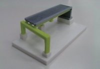
3D Physical Modeling Service offers customers the ability to produce a variety of 3D physical models using the outputs from UC-win/Road, UC-win/FRAME(3D), UC-1 Series and Allplan on a special 3D printer. For this service, we use a Zprinter 650, the highest spec model from Z Corporation. Zprinter 650 can create full color 3D models using inkjet printing method. It can produce physical models with a maximum size of 254mm (w) x 381mm (h) x 203mm (d), the largest in the industry
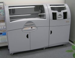 |
| ▲Photo1 Zprinter650 |
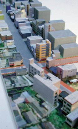
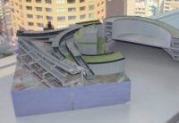
We are pleased to have had the opportunity to create a physical model of the streets for workshops of Buzenda Hosoe Town Planning Conference.
| Photo2 Shopping Streets of Buzenda Hosoe area, produced by Zprinter using the model created in VR space (Photo from Fukuda’s Blog, November8, 2010 “Buzenda Hosoe Town Planning Conference: VR+3D printer”) 【URL】http://y-f-lab.jp/fukudablog/index.php?e=1046) |
 |
Buzenda Hosoe Town Planning Conference is a workshop aimed at the inheritance and revitalization of local culture, promoted by people in Buzenda, Shimonoseki City of Yamaguchi Prefecture. From the viewpoint of building future for the city, active discussions are being made for specific town planning, including how road and arcades should be developed and renovated in future.
Associate Professor Fukuda, involved in this workshop as an environmental design expert, is introducing community development cases in Japan and abroad at his lectures and using VR made with UC-win/Road for examination.
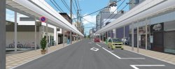
VR are being utilized to understand the current state of the district and share and examine future images, when ideas of shopping streets are being discussed,. VR data has been created, in which existing roofed shopping arcade are placed and members can switch to future model instantly to see the undergrounded utility wires, the arcade removal, and images of planted trees and a street cafeteria.
| Present | Undergrounded utility wires | |
 |
 |
|
| ▲Image1 Buzenda Hosoe Town Planning Conference At Buzenda Hosoe Town Planning Conference, future images are being examined by utilizing the current state of and planned images of the district. |
||
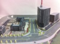
| ▼Image2 Example models produced by the 3D printer | ||
 |
 |
 |
| ▲Sakurada-mon area | ▲Tokai Loop Road | ▲Taishi Junction |
 |
 |
 |
| ▲Ohashi Junction(1) | ▲Ohashi Junction(2) | ▲Water intake gate |
Images above are present models or future models. (Image1) Various cases are being examined and several types of trees can be prepared for the plan, for example.
Associate Professor Fukuda proposed to create a model by 3D printer and utilize the model in the system linking the physical model with VR, believing that he has a lot of things to work to help non-design experts or non-VR specialists can examine the design and operate VR at their will". (Fukuda's blog)
Raw VR data is being used to create the model. Using “POV-ray to Max” plug-in option, which was jointly developed with Associate Professor Yoshihiro Kobayashi of Arizona State University, VR data of UC-win/Road, such as roads and intersections was converted to 3ds Max. In addition, the state of the polygon data was optimized by "Magic", a special program for creating 3D physical models and was produced by Zprinter650.
The output model is a 1/500 scale model of approximately 600m section of Buzenda Hosoe shopping district. The full length is about 1.2m but the model is divided to 5 sections for one person to can carry. The section models were output by twice and it took approximately 24 hours to complete the model. Producing full color models by the 3D printer allows creating models in dramatically short time, compared with making models using existing method and materials using Styrofoam, cardboard and wood.
This model, reproducing the road, the road crossings and the surrounding buildings created by UC-win/Road, will be used for the City Presentation System which is being developed by Associate Professor Fukuda.
City presentation system is the system in which VR data of UC-win/Road is linked with physical models. Laser pointing on the model is sensed by the sensor and it allows navigating or changing the view direction to the pointed spot in VR space. The system is composed by models, a laser pointer, a monitor to display VR space and UC-win/Road. Watching the VR space and pointing the spot to which you want to view or move, the spot is captured by the web camera and is reflected in the VR space on the display. The system is really a combination of the advantages of physical model, which allows intuitive comprehension by directly touching the model and VR, which allows flexible simulation such as traffic representation and switching of weather conditions.
This system is being introduced in the book, “Introduction to Programming for Civil Engineering and Construction Engineers - SDK Programming Delphi of VR and structural analysis” (published by Nikkei BP). Please refer to this publication for more details.
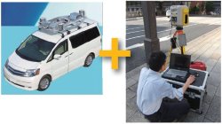
FORUM8 is providing service "3D Scanning Service", in which FORUM8 scans buildings and roads with 3D laser scanner and makes models. The 3D laser scanner allows scanning 5000 points per second and the scanner boasts proven track record in measuring and surveying topography and buildings.
Point Cloud Modeling plug-in option of UC-win/Road Ver.5 allows you to import scanned data as point cloud data model and represent the shape of existing structures such as buildings and bridges in VR environment. The plug-in option can import the formats such as xyz, csv, txt, asc and can also read coordinates and color information.
Below some of the projects this service has been ordered with.
| Image2 Where MMS (left) cannot be used because cars cannot enter, a stationary 3D laser scanner (right) is used. These points cloud data are combined to create VR data. |
 |
In the project to measure a building from all directions for the renovation of the company-owned building, we have created ortho images by adjusting the distortion by using the measured points in the software. Instead of measuring the exterior dimensions of the building and drawing an elevation, measured data of the existing buildings is being used for the repair plan.
MMS (Mobile Mapping System Mitsubishi) are well known as point a cloud data measurement method. In MMS, a special vehicle, equipped with an integrated unit including GPS antennas, cameras and laser scanner is used. The system allows measuring large number of points automatically while driving, however it cannot measure where cars cannot enter. On the other hand, since the 3D laser scanner FORUM8 is using is a stationary type, it allows measuring at the narrow space where vehicle cannot enter or measuring from a distant place, complementing the weaknesses of MMS.
Currently, we are involved in a project to measure by MMS the whole company-owned site, the surrounding road and the whole area along the roads. MMS measurements are complemented by laser scanner measurements, point cloud data by MMS measurements and laser scanner measurements are imported to UC-win/Road Ver.5 and VR data are created by referencing to the point cloud data.
In the joint research project of measuring point cloud data, collaborating with Professor Motoya Yamasaki of Tokyo University of Agriculture and Professor Kawamura Akira of Kitami Institute of Technology, we are measuring at Shibuya Crossing and Nihonbashi Chuo Street, data of the Shibuya intersection has been collected as sample in UC-win/Road Ver.5.
FORUM 8 is offering the tripartite “3D VR Engineering Service” consisting of "3D Physical Modeling Service”, introduced here, "3D Laser Scanning and Modeling Service", and "3D Drawing Option for BIM / Report and Drawing Total Service”.
 |
| ▲Image3 Shibuya Crossing Data measured by Point cloud data measuring This sample data comes with UC-win/Road Ver.5 |
 |
||||
| BACK | LIST | NEXT |