New Products
AGUL
Remote farmland management project using AR.Drone customization system

Introduction system UC-win
Simulation
Introduction
AGUL is a system developed by costomizing AR. Drone(Parrot) with a purpose of agricultual support. AGUL confirms the growth situation of crops and pests and supports the management of the farmland by collecting the information from the sly with a camera, temperature sensor and humidity sensor. Since the surrounding image can be transmitted from the mounted camera in real time, AGUL can avoid the obstacle and can be operated from the distant place such as a home. 

Use Sensor
Management of farmland, environmental measurement FLY-DV camera, temperature sensor, humidity sensor
Flight management GPS, 9DOF IMU, infrared distance sensor
Flight control (AR.Drone) 6DOF IMU, ultrasonic altimeter, front camera, high-speed camera
■Chart 1 AGUL Customization Model mounted sensor
Feature of system
AR.Drone (Figure 1, 2) is a quadricopter which can be operated from smartphone and iPod. AGUL is operated from the interface on a PC with the mouse and keyboard and the data of communication information is exchanged by radio by using Wi-Fi. Since built-in computer controls the balance automatically, AGUL can be realized to move turning on the spot in addition to going up, moving down and turning from front to back and from side to side. 

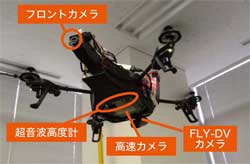
Three kinds of cameras are used for AGUL. The FLY-DV camera is used for the management of farmland and taking a video for recording. Interval timer shooting (automatic shooting per second) of QVGA(1280*960) and automatic video recording of VGA(640*480) are possible. The fromt camera and a high-speed camera can display the image in real time although their resolutions are poorer than FLY-DV camera. AGUL confirms with a front camera and high-speed camera and records the details with FLY-DV camera. 

GPS and 9DOF IMU(Inertial Measurement Unit)are used for flight management. GPS measures the position of AR.Drone. They make it move along the route which was set and avoid to fly out from the farmland. 9DOF IMU confirms the direction of AR.Drone by measuring the rate of acceleration, gyro and earth's magnetism. The distance sensor of infrared ray avoids collision with obstacle by measuring the distance from the front. These sensor information is exchanged by radio with a transceiver. Communication distance of Wi-Fi is about 50m but data can be obtained from the distant position due to using radio. 

Mbed(NXP) is used for the control of the camera and the sensor. Mbed, which is a small computer module, organizes the information of measured farmland and send it to PC for operation. The sensor for flight control is managed by the mother board which is integrated into A.R.Drone. It is used for controlling the balance of AGUL and adjusting the flight speed.

画像をクリックすると大きな画像が表示されます。 画像をクリックすると大きな画像が表示されます。
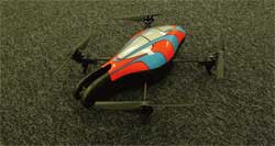
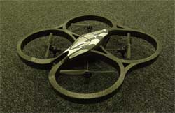
■Figure 1 AR.Drone(Parrot) in mounting hull indoor ■Figure 2 AR.Drone(Parrot) in mounting hull outdoor

画像をクリックすると大きな画像が表示されます。
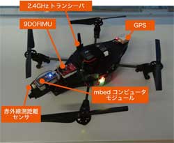
■Figure 3 AGUL customization

画像をクリックすると大きな画像が表示されます。 画像をクリックすると大きな画像が表示されます。
■Figure 4 FLY-DV camera ■Figure 5 Test flight of AGUL
Future development
We are now planning to develop the autonomous flight system operated from VR software such as UC-win/Road.  Automatically flight along the plan is possible by inputting the flight plan of flight route and movement speed on VR space. Confirming the taken video or obtained information on VR, the management is easy. Multicopter is to be adopted as a flight vehicle. It can support a wide range of applications by extending the flight time and mounting a new sensor. 
(Up&Coming '12 Summer Issue)
戻る
Up&Coming

FORUM8