CARVI 2008: Congress on Applications of Virtual Reality
EUVE - European Virtual Technological Centre
Vitoria-Gasteiz, Spain
(From the article)
Also during this conference (CARVI), where over 150 professionals from all over the world attended, a Japanese company called Forum 8 presented a VR system which is used widely for civil engineering projects. After interviewing Thea Lorentzen, an American who works at the company, we learned that in Japan, many aspects of new projects, for example, a new highway, are simulated and visualized prior to construction. This is critical for making group decisions and for creating a consensus among the people who will be affected by the project.


FORMULARIO
|
Name of the speaker: |
Photograph |
|
Thea Hack Lorentzen
|
|
|
Position of the speaker: |
|
|
Deputy Manager, Road Support Group
|
|
|
Company: |
|
|
Forum 8 Co., Ltd., Tokyo, Japan
|
|
|
Summary of the work experience: (maximum 150 words) |
|
|
As a part of the Road Support Group, Thea has been working on virtual reality
simulation projects created with the UC-win/Road program. Her work at Forum
8 has also included teaching training seminars in Southeast Asia and providing
support for international projects. She holds a B.S. in Civil Engineering
and a B.A. in History from Stanford University. Before joining Forum
8, Thea held summer positions with the General Services Administration's
New York Department of Public Buildings and was a research assistant for
Stanford's Civil Engineering Department. She is interested in visual explanations
of information and is excited about the possible applications of VR for
building consensus through visualization. |
|
|
Brief description of the company: (maximum 150 words) |
|
|
Forum 8 Co., Ltd. is a Japanese civil engineering software developer and distributor. Forum 8 has created a suite of civil engineering software, including UC-win/Road, a 3D real-time virtual reality program. It holds the top share for civil engineering software in Japan, but is also expanding internationally with offices in New Zealand, China, London, Singapore, and Delhi, as well as worldwide network of distributors. Apart from providing software solutions, Forum 8 also creates customized virtual reality data for clients who are often in the government, AEC or consulting industries. Many projects and customized development are worked on with universities and research organizations and each year, Forum 8 holds a contest where users submit their VR data. In hopes of expanding the use of VR globally, Forum 8 now holds an annual VR symposium where 8 professors from around the world exchange ideas and present their work.
|
|
|
Title of the presentation: |
|
|
3D Real-time Virtual Reality Applications: Case Studies in Asia
|
|
|
Summary of the presentation: (maximum 1500 words) |
|
|
UC-win/Road is a 3D real-time virtual reality software program with a wide
variety of applications; Today's talk will focus primarily on the use of
simulation as a tool for improving infrastructure and public safety. PUBLIC ANNOUNCEMENTS Ishikawa-cho Junction, Metropolitan Highway Company, Kanagawa Bureau, Japan
When a new expressway exit was created to help decongest the link between Tokyo and Yokohama, authorities wanted to make sure that people could immediately make use of the new access route. The VR data was created, used initially for planning meetings, and then posted in a web-viewer program. The simulation serves as an online public announcement and includes drivers' perspective scenarios as well as voice-over directions and signal information. CONSERVATION Ecological Restoration in the Yunnan Province Erhai Lakeside Area, Shanghai Institute of Waterways
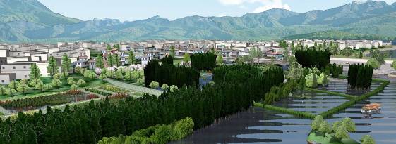
The Yunnan province was a desperately polluted area but community members were unable to convince authorities that a comprehensive clean-up was necessary. In order to gain approval and grant money for the restoration project, the Shanghai Institute of Waterways decided to create a visual model of what the area could look like if it were restored to its natural state. Clean water, foliage, and wind were all simulated with the use of rich texturing and the project was successfully persuasive.
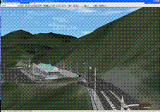
EVACUATION SIMULATION Qingdao JiaoZhou Bay Tunnel Project, Nepoch Consultant Co., Ltd., China
With increasing economic activity in Qingdao area of China, developers wanted to connect Qingdao city to a neighboring island. Because this would mean constructing a very long tunnel, the planners needed to present verifiable evacuation solutions in order to gain approval for the project. Evacuation analysis data was imported into UC-win/Road where the virtual environments and scenarios were created. This simulation models the traffic flow leading up to an accident occurring within tunnel. The accident stops all cars, and people must get out of the vehicles to escape through the tunnel's emergency exits. Each person's evacuation route and location coordinates are visualized according to the evacuation analysis software results.
DRIVING SAFETY RESEARCH Driving Ability Measurement for Senior Citizens VR Simulation, Meijo University, Faculty of Science and Technology, Department of Information Engineering
Students at Meijo University conducted a research project to analyze the reasons behind the high number of senior citizen car accidents. They created VR scenarios and brought in subjects to test and record driving behaviors. Numerical data such as driver reaction time and braking distance could be extracted from the scenarios. This project was also completed in conjunction with a driving school which used VR environments to teach drivers how to respond to unexpected scenarios. (There has been an increased demand for using VR data in training settings such as phobia therapy and flight schools, for example.)
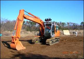
CONSTRUCTION MANAGEMENT Man-Machine Interface by Remote Control, Japan Construction Method and Machinery Research Institute, Civil Engineering Laboratory
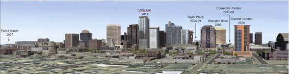
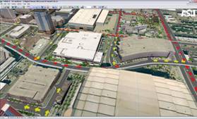
Recently, Forum 8 has been co-developing a remote-control system that enables the reception of information via wireless LAN from construction machinery equipped with a GPS and terrain laser scanning system. Movement is defined in 3D models and users can monitor progress in real time. URBAN PLANNING Digital Phoenix Project, Arizona State University, College of Design
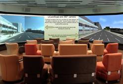
The Phoenix Skyline in 2011 A VR model of downtown Phoenix, Arizona covers a 1 mile x 1 mile square area and visualizes traffic patterns and future developments in the built environment. Scenarios can predict what traffic grid will look like if, for example, in 2011 the stadiums, convention center and opera hall have events at the same time. A new light rail system, aimed to be completed later this year, is also included in the traffic analysis. Most of the buildings, lane conditions, traffic signals, lights, and stop signs in the area have implemented in the model and visualized in a real-time, fully 3D environment. The Digital Phoenix Project is still being worked on by Arizona State University professors and students who are hoping to mitigate Arizona's urban sprawl problems by facilitating better urban planning and visualization of development. They are also experimenting with using the model in an immersive theater and in connection with tangible interfaces.
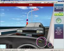
PUBLIC EVALUATION Fukui Coastal Route Drive Simulation, Fukui, Japan The Fukui coastal highway route is renowned for being the site of many accidents. In the process of reconstructing a safer road, a customized simulation and hardware set-up was made to record driving errors. Currently, the driving simulator is placed in a rest stop along the highway. Drivers can stop by to take a break, and try driving virtually down the same route. The simulator instructs drivers on how to better navigate the road. Messages and signals are included in the scenarios, oftentimes warning drivers of a dangerous upcoming curves or bad weather.
Most notably, this simulation system also collects information about drivers' concerns and mistakes (e.g. if they come too close to a guardrail). The data is then used to advise planners and guide the current highway construction work. This case study is exemplary of the ways in which VR can help pull in direct public involvement to help create safer roads. In summary, we see that the most frequently used tools for civil engineering project design and planning often fail to account for real-life conditions, visual qualities, and environmental obstacles that come with implementation. Yet, VR offers a new way to negotiate constraints and possibilities. As we look to improve our future infrastructure and make it more sustainable, we will need many people from different disciplines to be involved in construction planning. We are excited that this virtual reality tool might enable more non-engineers to participate in the design process.
|
|


Page Top
