UC-win/Road Shape File Plug-in UC-win/Road Shape File Plug-in |
UC-win/Road Data Exchange |
 Beginning
Shapefile was developed by ESRI since early 1990s and is now the most widely used format in GIS.
Shapefile does not only involve a single file format but GIS data consisting of several files. One data set requires a minimum of three files (shp, shx, dbf) and a maximum of eight other different option files.
ESRI (SHP), the format which space and non-space data is saved, as well as CAD data (DXF), is compared in the following table.
 The comparison of SRI(SHP) and CAD data (DXF)
| Category | shp | dxf |
| General | A single layer exists in each file. Binary format Attribute information exists separately. |
dBASE III DATABASE format exists. Attribute data allows the expression of several styles of theme. |
| Spatial Data | Several spatial formats exist. Each spatial format exists in a layer. Spatial style, Zvalue can be involved in the attribute information. |
Simple spatial format Several spatial formats exist in each layer. Spatial style exists in spatial information. |
| Attribute Information | dBASE III DATABASE format exists. Attribute Data allows the expression of several types of theme. |
It is essential to create the link with an external database. |
It can be used for terrain, road, lake, river corresponding with "vertex, polyline, polygon" of geometric information. In addition, attribute data is also included when making use of data.
In a bid to allow bi-directional import/ export of relevant information, UC-win/Road is now able to import Shapefile. This can be utilized by the basis data import function, which is integral is creating VR space by adding the LandXML Plug-in to UC-win/Road.
OverviewImport Element:
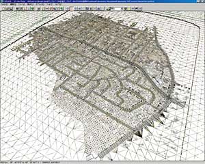
This time, Shapefile Plug-in targets terrain, road alignment and building data.
3D visualization and simulation can be done by converting the vector data of Shapefile into the relevant format for UC-win/Road. More information is available on the following.
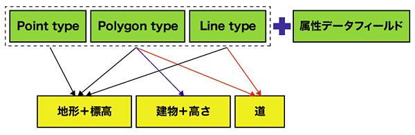
Terrain:
It converts Shapefile into terrain patches of UC-win/Road by combining plain vertex information and elevation attributes.
|
 |
Road Alignment:
It obtains polyline data from Shapefile and converts the road alignment. 2 conversion methods are developed.
Method 1: convert to spline road by setting the vertex of polyline as turning point.
Method 2: convert to road using IP method by setting the vertex of the polyline as an IP point.
Road is created automatically by alignment settings.
|
 |
 |
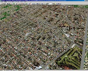
Building Models:
It obtains the height information and plain outline polygon of building and converts them to UC-win/Road 3D building models.
Designation of Texture image is available in import.
 |
 |
UtilizationData Access Option, which connects directly to GIS format and business data, allows time and energy conservation.
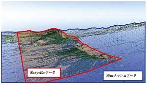
New ImportIt allows the creation of a new project using Shapefile information on 50 meter mesh terrain data.
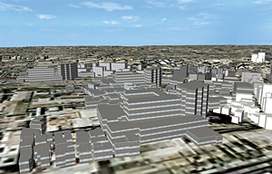
Synthetic ImportShapefile can be integrated with existing data. Reality of VR space can be more improved by Making new roads, construction project models and building roads.
 |
 |
UC-win/Road for GIS(Geographic Information System)UC-win/Road for GIS consists of basic components of geographic information data mapping, management, editing and analysis.
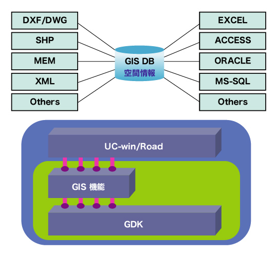
The system that is being developed will be able to support references of spatial data on surface, registration of input, spatial operations, database management, problem analyses and 3D visualization to deal with various kinds of information.
This system is utilized for consensus formation, such as facility management, urban projects, environmental assessment, and hazard prevention. It also allows analysis and management of facilities and geographical information on simulation space through linkages with UC-win/Road
Powerful Data Access Option
Imports from several type of Vector, Raster and DB file, and Exports to other file format are available.
| Vector Data | Raster Data | DB and TEXT |
| GEOMania (*.gdf) AutoCAD(*.dxf/*.dwg) ESRI Shape (*.shp) MapInfo MIF/MID(*.mif) MicroStation Design(*.dgn) NGI Binary (*.nbi) NGI ASCII (*.ngi) |
Bitmap(*.bmp) JPG (*.jpg) GIF (*.gif) TIFF (*.tif) GeoTIFF(*.tif) Window Meta File(*.wmf) |
MS Excel (*.xls) MS Access (*.mdb) Text (*.txt) |
Spatial Operation and Analysis Function "GIS+CAD=Powerful Mapping"
UC-win/Road for GIS supports the link of GIS data with CAD data. "GIS+CAD=Powerful Mapping" It allows editing and management of spatial and attribute data. There are plans to support various operations such as unions, relative complements, intersections and symmetric differences, buffer analysis and chart analysis.
3D Terrain Analysis Function
It allows the editing of 3D geographic information such as slope, direction, shadow, visible distance, stratum by making use of terrain data.
 |
 |