
| 3D survey data after process solution service |
- We introduce the newest features of UC-win/Road Ver .5, Point Cloud Data Plug-in option. On this page, the following functions are explained: the point cloud data editor; road centerline extraction; road alignment and cross section generation and road editor; road section extraction; and road section creation and road section editor.
- Point Cloud Data Plug-in's basic functions are to display 3D point cloud data in UC-win/Road VR space and depict the point cloud data at the designated position correctly. This plug-in can also extract data, import additional data and adjust the display position by moving the points sideways or by rotating them in VR space. In addition, this plug-in can also generate TIN data (ground and seabed data) based on the point cloud data, and overlay textures and import color from aerial photographs onto the point clouds.
This plug-in is also able to export terrain data produced using point clouds in LandXML format to be used in other software systems.
As a post-processing function, this plug-in can extract road alignment data and cross section data and use them in UC-win/Road to model roads almost automatically.

Maximum number of point cloud data
- 32bit OS(Windows XP) : less than 16 million points
- 64bit OS(Windows Vista, Windows 7) : more than 25 million points
Main edit functions
- Point cloud display
- TIN terrain data generation
- Extraction of road alignment and cross section information
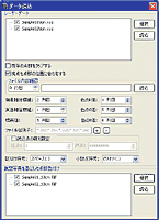
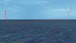
- Road center lines can be extracted using automatic search and manual assignment. Automatic search utilizes the measurement feature of the mobile scanning device (e.g. MMS ? Mobile Mapping System) whereas manual assignment generates continuous linear regression arbitrarily as the user selects point clouds manually.
- The X (east-west) and Z (north-south) alignment data of the extracted center line point clouds is linked to the road alignment editor in UC-win/Road for road creation and editing.
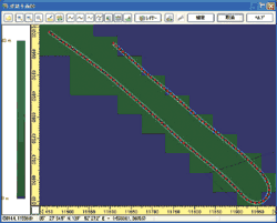
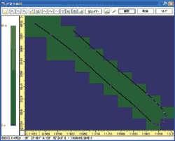
 Aerial view (point sequence)Aerial view (road alignment)
- The L (length) and Y (elevation) information is linked to the road cross
section editor in UC-win/Road to edit the vertical alignment of the road.
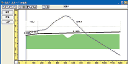
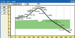 Cross section (point seqence)Cross section (alignment)
- Road section information is extracted by automatically extracting point
cloud data from inside a large rectangular frame and generating point sequences
of the road section.
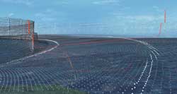
 Point sequence and the point cloud of the road sectionPoint sequence of the road section
- Point sequence of the road section is linked to the road section editor in UC-win/Road to create and edit the road section.
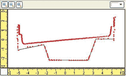
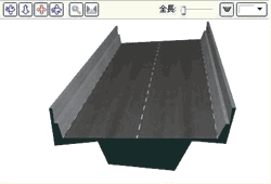 Point sequence and the road sectionRoad section in 3D
- Based on the road alignment data and the road section data that were generated
above, road modeling in UC-win/Road can now be carried out.
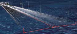
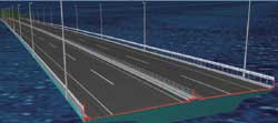 Point cloud data onlyRoad model
UC-win/Road Ver.5.0 point cloud data planned release date: August 2010