FORUM8 is very pleased to announce their latest Premier Partnership Agreement
with French Geo-Data specialists SIRADEL..
FORUM8 and SIRADEL have developed a seamless integration of FORUM8’s
award-winning 3D Visual Interactive Simulation software VR-Design Studio
and SIRADEL’s 3D City models.
This exciting new development of being able to offer pre-built SIRADEL
3D City models within VR-Design Studio will undoubtedly save a huge amount
of time and money for FORUM8 customers and partners alike who require an
interactive 3D model of a town, city or streetscape as a part of a current
or future project.
SIRADEL has been producing accurate and realistic 3D city models for more
than 15 years and has built up a unique collection of 3D digital models
of thousands of cities from all over the world. SIRADEL is a top-tier editor
of geographical map data in the world and controls the whole production
chain, from the image acquisition (aerial, satellite and terrestrial) to
the post-production. SIRADEL’s databases are updated on a regular
basis – on average every three years.
Siradel is based in Rennes, France and is led by its president Laurent
Bouillot. The company provides clients with 3D city models primarily for
the telecoms market and have customers in over 65 countries. Siradel use
photogrammetric techniques to build their city models based on high quality
oblique aerial images.
The RealCity3D urban databases come in 3 levels of realism, with a metric
geometric precision. SIRADEL has also developed a unique and operational
Mobile Mapping System which automatically texture maps building’s
fašades and monuments in a cost-effective manner for even more realism.
This cutting-edge technology is an economically viable alternative for
all who wants to increase the visual fidelity of their 3D city models on
a large scale, for example for real-time pedestrian navigation, evacuation
or driving simulation.
FORUM8 and Siradel first came into contact at an ITS exhibition in Lyon
France, in which FORUM8 showcased their 3D VIS technology and Siradel’s
Innovation & Business Development Manager Christophe Papin visited
FORUM8’s booth. Siradel was interested in being able to offer
FORUM8’s 3D VIS software to its clients and FORUM8 was keen on integrating
Siradel’s pre-built 3D model into their 3D VR space, hence they arranged
a meeting following the show to examine the possibility of a partnership
agreement that would benefit both FORUM8 and Siradel as well as their clients.
FORUM8’s development team and Siradel’s technical staff worked
together to develop a seamless integration of FORUM8’s award-winning
3D Visual Interactive Simulation software VR-Design Studio (formerly UC-win/Road)
and SIRADEL’s 3D City models and that’s how the agreement came
into place.
FORUM8’s state-of-the-art 3D software VR-Design Studio (formerly
UC-win/Road) is at the forefront of modern Interactive 3D Simulation &
Modeling technology.
VR-Design Studio is the ideal solution for urban and transport planning
& design projects, either on its own or linked with third-party civil
engineering 3D design tools and micro-simulation applications. It is also
used extensively in human-factors research, in conjunction with a wide
range of drive simulators and for pedestrian and rail based VR projects.
With this partnership agreement in place, FORUM8 can now provide partners,
clients and prospective clients worldwide with their own highly precise
3D City Model. In addition, using the power of our interactive 3D simulation
and modelling software VR-Design Studio, numerous realistic simulations
can be embedded into the city model to enable it to be used in a wide range
of applications - from stakeholder consultation to road safety driver training
and emergency planning projects. We expect to see a revolution in city
modeling starting from the latter half of this year.
 |
 |
| Example of 3D city model created by SIRADEL (Rennes/ France) |
 |
 |
 |
 |
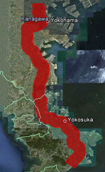
| Data model (Tokyo and Yokohama, Japan) available for sales |
 |
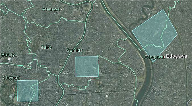
High Resolution 3D Database Target Area The following 3 areas
in Tokyo (Light blue of the above map : Left, Middle, Right)
| Left |
: |
Area around the vicinity of the border between Chiyoda-ward and Tyuo-ward
(Including Tokyo station and a part of Imperial Palace) |
| Middle |
: |
Southeastern part of Sumida-ward (In other words, the vicinity of Kinshi-tyo
station of JR Sobu line) |
| Right |
: |
Area around the vicinity of the border between Edogawa-ward and Katsushika-ward
[Northwestern part of Edogawa-ward (between Arakawa River and Shinnakagawa
River) and Southern part of Katsushika-ward (just South of the point where
Nakagawa River and Shinnakagawa River merge). In other words, the vicinity
of Kinshi-tyo station of JR Sobu line] |
|
|

