Simulation by 3-D Real-time VR Makes a Difference At Local Meetings and the Open House
Let us introduce Matsuyama Office River and National Highway. Its headquarters are located just in the heart of Matsuyama Airport and Matsuyama city center. Matsuyama Office is one of the offices under the control of Shikoku Regional Development Bureau, MLIT (Ministry of Land, Infrastructure and Transport).
The Office adopted Forum 8's "UC-win/Road" in summer last year, when Matsuyama Outer Ring Road Project, one of the most important highway projects for the Office, was about to start on a full scale, and the discussion was going on how to carry out. We interviewed Mr. Keiji Furuichi, Chief for Planning, The second Survey Division of the Office, who started his duties in 0ctober last year (prior to the start of the design briefing meeting) and took charge of a series of meetings.
Matsuyama Office River and National Highway is in charge of maintenance of the two rivers running through Matsuyama City, the Shigenobu and the Ishite, and main national highways in Chuyo (Matsuyama City and the surrounding area) and Toyo (Niihama City and the surrounding area) in Ehime Prefecture.
Unlike a typical river, the Shigenobu has been well known as "Abare-gawa (river prone to cause flood)" since a long time ago. It originated 400 years ago when the Iyo river flooded repeatedly after torrential rain. There is an anecdote that Kato Yoshiaki, then-castellan of Matsuyama Castle ordered his vassal Adachi Shigenobu to modify the river, and that his achievement led to the renaming of the river to: the Shigenobu. This story may help you understand the background of the river.
In recent years, Shikoku region has often been suffering from water shortages. In such instances, the dam plays an important role in water regulation. Constructed in 1973 at the upper stream of the Ishite, the Ishitegawa Dam contributes to the local community not only as the source for the continuously expanding city of Matsuyama, but also by providing water for agriculture and disaster prevention.
Matsuyama is a place with a nice mix of history, culture, and nature. In addition to its warm climate, it is surrounded by the Inland Sea and the Shikoku Mountain Range, and is well known as the locale of novels like the one written by Soseki Natsume. This explains why the city has been a source of attraction for many people as a holiday destination. This is also supported by added appeal and improved accessibility realized by Setouchi Shimanami-Kaido (Nishiseto Expressway), Matsuyama Expressway, and so on.
That being said, the traffic volume flowing into the city of Matsuyama has been increasing year by year. It is reported that it has increased by more than three times in the past 10 years. For this reason, national highway improvement projects within the Office districts focus on how to plan safe and smooth road construction with emphasis on congestion mitigation.
Matsuyama Office River and National Highway have 5 branches --- Shigenobu River Branch Office, Ishitegawa Dam Managing Branch Office, Saijo National Road Maintenance Branch Office, The First Matsuyama National Road Maintenance Branch Office, and The Second Matsuyama National Road Maintenance Branch Office, where 116 staff are employed in total (45 administrative officials, 22 river engineering officials, 49 road engineering officials, as of October, 2005.)
The highway road network in Matsuyama City is made of trunk roads like National Highway route11, 33, 56, and 196 expanding radially from the city center where facilities like Matsuyama Castle, Prefectural Government, and the city hall gather. Hence, the structural cause for congestion from concentrated traffic flowing into the city center was discovered at an early stage. Then, Matsuyama Ring Road was constructed as its solution and its full operation started in 1999.
The provision of the Ring Road brought about the effect of congestion mitigation in the city center area. However, it also resulted in the acceleration of the suburban area as a bedroom town and the increment of large-scale stores along the Ring Road. As a result, the traffic volume on the Ring Road increased rapidly. It exceeded 50,000 cars per day, reaching saturation point. Especially, The intersections of the Ring Road and the aforementioned radial roads are chronic congestion points.
This led to another effort to deal with constructing Matsuyama Outer Ring Road as a solution for congestion mitigation of Matsuyama urban area.
This is a plan to construct another Ring Road outside Matsuyama Ring Road as "Local High-Standard Highway" in order to disperse the traffic flowing into the city as well as to improve accessibility that also contributes to the regional development of Matsuyama Urban Area by connecting nodal points of transportation in wide area and regional development lodgments including Matsuyama Expressway (Matsuyama Interchange), Matsuyama Airport, Matsuyama Port, and FAZ (Foreign Access Zone).
"It can be said that Outer Ring Road is now of the highest priority among the projects within our district, " said Mr. Furuichi. He expects that its construction will help to ease the ongoing traffic that has been the main cause of congestion in Matsuyama City, and promote increased ease of flow via congestion mitigation.
At present, the section between National Highway route 11 and 56 (6.8 km long) is decided as a city plan, and Matsuyama Outer Ring Road INTER Line between National Highway route 33 and 56 (4.8 km long) has already been initiated as a project.
That section consists of a motor road as a main part with ordinary roads along both sides, each of which is a combination of a one-way roadway and a bicycle and pedestrian track. Ministry of Land, Infrastructure and Transport (Matsuyama Office River and National Highway) is in charge of the motor road. With regards to the ordinary roads, the east side of the Prefectural Road (Matsuyama-Iyo Route), which lies almost in the middle of the project section, is covered by Ehime Prefecture, while the west side is covered by Matsuyama City.
Along with the Matsuyama Outer Ring Road Project, the Office is also working on the examination of various measures for congestion mitigation such as providing 4 traffic lanes with the radial roads, multi-level crossing of the main intersections in Matsuyama urban area such as Jiccho Intersection and Kosaka Intersection.
Mr. Keiji Furuichi explains about the project of Matsuyama Outer Ring Road INTER Line by saying, "This 4.8 km long-section includes a lot of elements."
 |
|
 |
 |
 |
|
 |
 |
 |
 |
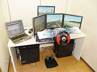
Simulator, produced by "UC-win/Road" |
|
 |
|
In addition, as this is a joint venture of Nation, Prefecture, and City, it is important to seek building consensus of each promoter.
In addition, the enforcements of Policy Guidelines for Developing a Beautiful Country (published in July 2003) and Landscape Act, which is based on the former, led to the establishment of "Committee for Landscape of Trunk Roads in Matsuyama Urban Area", which is formed by people with learning experience in 2003. The committee also deals with the Matsuyama Outer Ring Road INTER Line Project by discussing visions of landscape development pertaining to the project.
On the other hand, dealing with the social tendency to demand improved accountability for infrastructure projects, the Office has been eager to explain the project to general public effectively and efficiently. For example, an information center has been established for the aforementioned multi-level crossing projects of Kosaka Intersection and Jiccho Intersection. Operating a portal site is another example, too.
The initial phase of Matsuyama Outer Ring Road Project involved holding "design briefing meetings" for the local residents so that they can obtain a better understanding of the project scheme. Next, an "Open House" event was conducted to allow more people to visit and understand the current development.
Design briefing meetings were held at 5 places during the term between November last year and February this year. In these occasions, instead of only using traditional two-dimensional drawings and perspective drawings, simulation technology of "UC-win/Road," three-dimensional virtual reality (VR) with excellent visual representation was adopted. "Our attempt to let people experience three-dimensional relationships of locations as well as traffic flow after the completion of the project was just as effective as we had expected," Mr. Furuichi reviewed.
Based on these experiences, the Office has established "Mogurin's Open House" in Matsuyama Store of Jusco to be opened from September 22 through the end of October this year. Aiming to project and present a wholesome view of congestion mitigation countermeasure projects that are addressed in Matsuyama City, panels and models are displayed in the Open House. To complement the above mentioned event, a driving simulator, an upgraded version of the one used in the design briefing meetings,was installed so that visitors can experience driving simulation on the 4.8 km-long section of "Matsuyama Outer Ring Road INTER Line" by VR.
Mr. Keiji Furuichi says that he is paying attention to diversified availability of VR and that he would like to try more advanced way of utilizing it, taking some elements like cost into consideration.
We would like to extend our heartfelt appreciation and gratitude to the individuals who took time off their busy schedule for our interview.


