Measuring and modeling point cloud data by 3D laser scanner
Japanese
3D Laser Scanning and Modeling Service
Service Start Date:2010.07.13
Service Overview
In the surveying and construction industries, there is a growing interest in 3D modeling using point-cloud data, which is collected using high-precision mobile GPS device.
In UC-win/Road Ver.5, there is a new function that enables users to import and edit point cloud data in real time (UC-win/Road Point Cloud Modeling). There is a variety of uses for this new feature.
Previously, point cloud data was solely used as reference points to be displayed or used in converting to 3D. Whereas, the point cloud data modeled in UC-win/Road can be used in various ways, such as to verify projects with 3D models and VR models that were created during the planning stage with high precision by measuring accurately the complete 3D objects and roads.
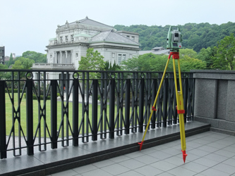
▲Fig.1 3D laser scanning
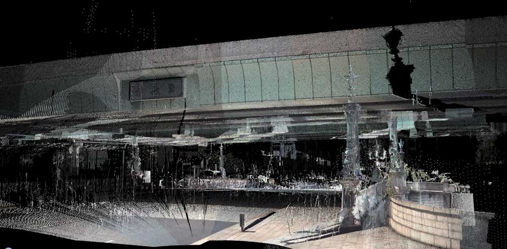
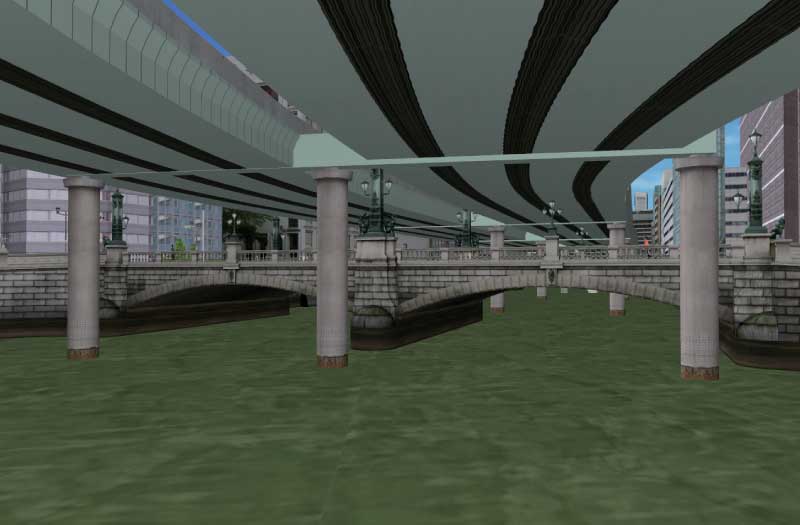
▲Fig.2 Point cloud data imported into
UC-win/Road (Nihonbashi, downtown Tokyo)
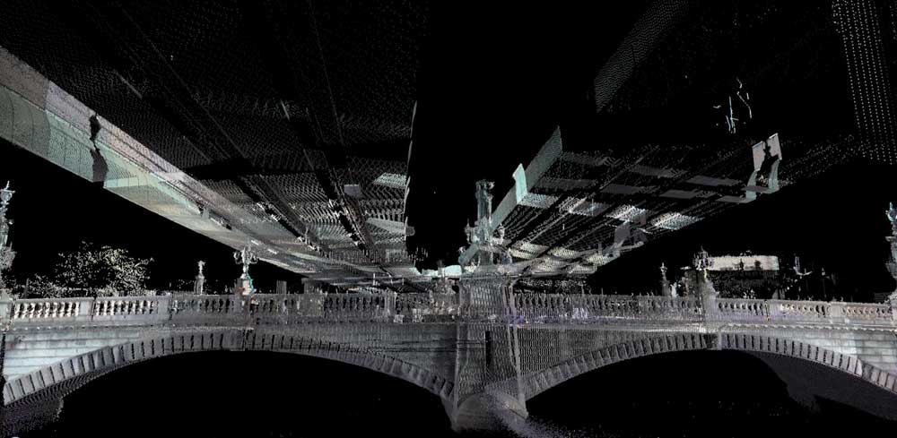
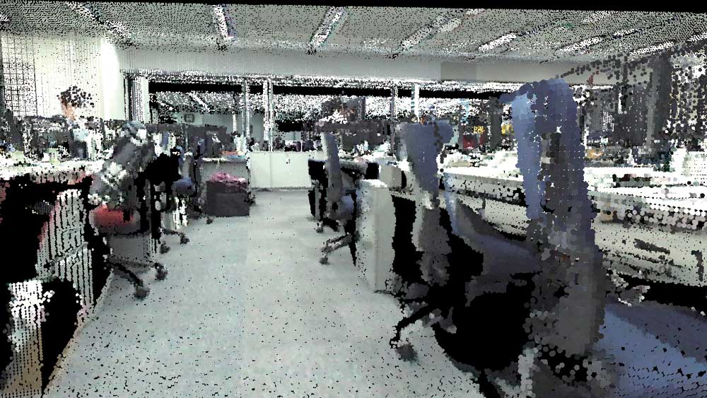
▲Fig.3 Point cloud data imported into
UC-win/Road (Nihonbashi, downtown Tokyo)
FORUM 8 is launching "3D Laser Scanning and Modeling Service" using Nikon-Trimble's 3D laser scanning device. Using this service, customers can receive assistance in collecting and modeling point cloud data.
Since we start offering VR modeling service (UC-win/Road Support Service) using point cloud data provided by clients at the same time, we are able to provide VR modeling service using data provided by clients and data provided to clients.
FORUM8 has already imported point cloud data and tested them, with the help of various scanner makers, thus, we can guarantee that we are able to display and edit of data with more than 20 million points in real time.
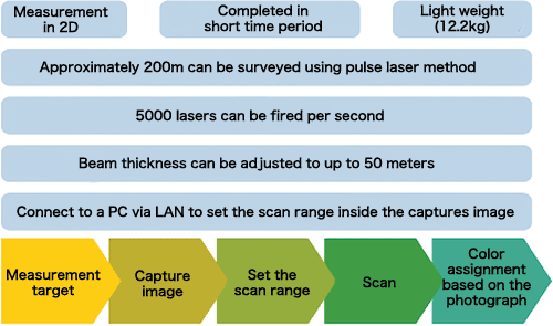
3D laser scanning service has following features, and the procedure begins with decision of the measurement position, the scanning and then the post-processing, as shown in the below diagram.
Point cloud data model in color can be acquired as above.
UC-win/Road Point Cloud Data Plug-in option can be used to generate TIN data from laser-scanned point cloud data and model the terrain using terrain patch function, as well as to import point cloud data.
Positions of the point cloud data can be adjusted by moving in parallel and rotating them inside the 3D space.
With the plug-in's data export function, users can export the terrain data, generated from the point cloud data, in Land XML to a third party program.
Related Information
- ◆BIM&VR 3D・VR Engineering News
-
BIM&VR 3D・VR Engineering News(Up&Coming)
- ◆Seminar
Overview and Features
3D Scanning and Modeling Service: Sample quotation
-
3D Scanning Modeling 3D scan measurement of 300m of standard urban road, including two reference point measurements for coordinate acquisition. Measurement is done in pairs, and one traffic controller and the application fee for measurement will be charged. The preparation for the measurement and post-processing of the measurement data is included. Section length 300m Survey location 2 locations Survey time 1 day Preparation and post-processing 2 persons x total of 1 day Total cost USD2,500 3D VR Modeling We create VR data using measured point cloud data. The VR space is arranged at a high level based on the point cloud (UC-win/Road quote Excellent B Level). The creation of 20 buildings, signs, 2 types of 2D trees, and power poles are included. Terrain, linear, 3D model,
texture processing300m
(Standard quote for UC-win/Road data creation)Modeling of buildings,
signs and plantsBuildings x20
Signs x5
3D tree x2 typesTotal cost USD6,400

Sample images
-
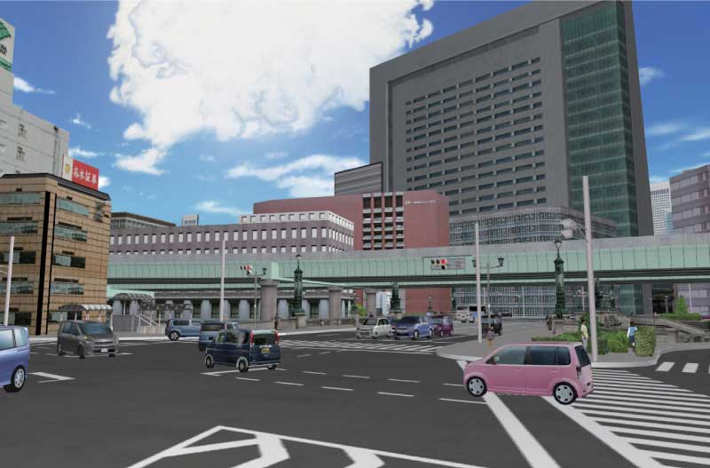
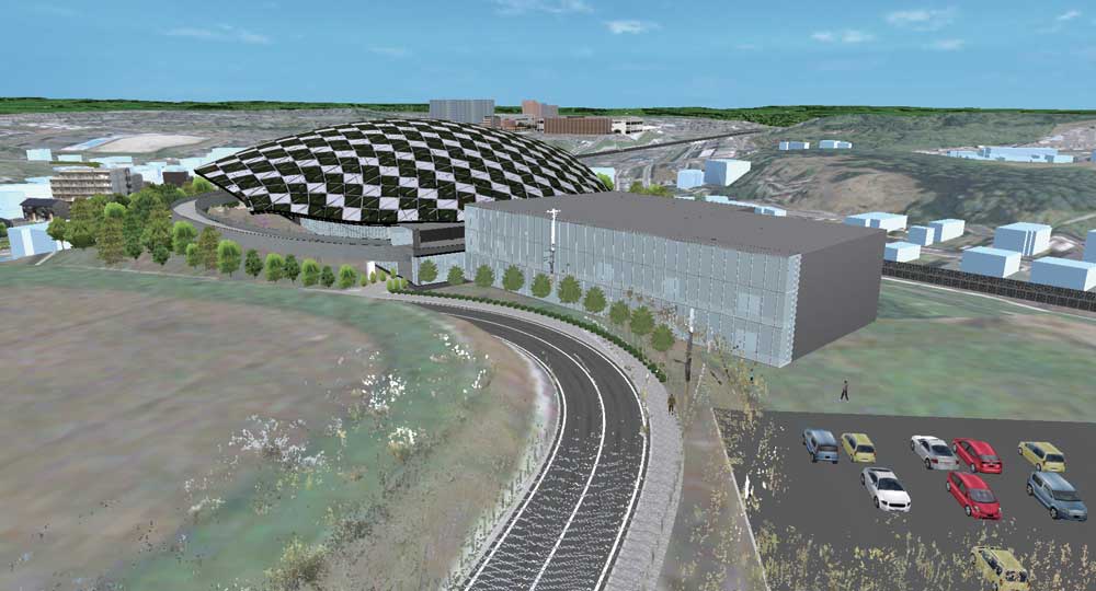
▲Examination on scenery
using point cloud data
(BuildLiveTokyo2010)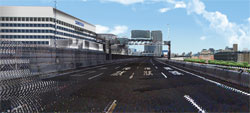
▲Hanshin Expressway (The 9th 3D・VR
Simulation Contest Grand Prix:
Kansai University Faculty Informatics)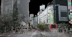
▲Shibuya Intersection
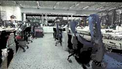
▲FORUM8 Tokyo HQ


Order / Contact Us
Order / Contact Us
-
Order
Contact us from Sales inquiry or email to ist@forum8.co.jp
サービス価格
EXODUS/SMARTFIRE 解析支援サービス標準見積表
-
価格は税別表示です
● 作業概要
●buildingEXODUSによるモデル化
フロア数= 1 フロア
延床面積= 1,000 m2
避難者数= 60 人
(1) 避難シミュレーション解析を行います。 (2) 各種図面はCADデータで提供され、その図面に基づいてノード/アークモデルを作成するものとします。 (3) ノードのタイプのみを考慮し、その他の条件は初期設定値とします。 (4) 避難者(OCCUPANT)の条件は初期設定値とします。 (5) 火災シミュレーション解析結果は考慮しません。 (6) 毒ガス(TOXICITY)サブモデルおよびハザード(HAZARD)サブモデルは考慮しません。 (7) 以上の条件に基づく入力データの提供をもって納品とします。
モデル化データ作成基本単価
(フロア数1。延床面積1000m2以下。避難者数100人。毒ガス・ハザード考慮なし。その他条件初期設定値。)技術者種別 工数 技術者単価 計 主任技師 20% ¥55,300 ¥11,060 技師A 30% ¥48,700 ¥14,610 技師B 30% ¥40,600 ¥12,180 技師C 10% ¥32,700 ¥3,270 技術員 10% ¥27,900 ¥2,790 (A) モデル化データ作成基本単価 ¥43,910
基本条件 割増項目 割増係数 入力 見積割増係数 基本作業のみ(必ず1.0を入力) 1.0 1.0 1.0 フロア数が1フロアを超過した場合の割増 1フロア超過毎に0.1増 1 0 延床面積が1,000mを超過した場合の割増 1,000m2超過毎に0.1増 1,000 0.0 避難者数が100人を超過した場合の割増 10,000人まで100人超過毎に0.1増
10,000人超は100人超過毎に0.05増60 0.0 資料整理(設計図書、図面、データファイル等) 0.1 1 0.1 (B) 割増係数小計 1.1
追加作業金額 作業内容 単位工数 入力 見積追加金額 タイプ以外のノード条件の修正
作業単価=基本単価(A)、入力=延床面積
[割増係数=1,000mまでは0.2、1,000m超過毎に0.2増]1 ¥0 避難者条件の修正
作業単価=基本単価(A)、入力=避難者数
[割増係数=100人までは0.2、100人超過毎に0.2増]1 ¥0 火災シミュレーション解析結果の考慮
作業単価=基本単価(A)、入力=ゾーン数
[割増係数=10ゾーンまでは0.2、10ゾーン超過毎に0.2増]1 ¥0 その他条件の修正 1 ¥0 (C1)追加作業金額
¥ 0
打合せ作業見積額 モデル化データ作成内容 単位工数 入力 見積打合せ金額 基本条件打合せ
作業単価=(技師A+技師C)×0.5の単価、入力=打合せ回数1 ¥0 (C2)打合せ作業見積額 ¥0
経費 技術経費 急行料金(25%割増残業等) ソフト、ハード購入費用 機器レンタル、持ち込み 交通費実費 その他 (F) 経費小計 ¥0
直接人件費 (D) 合計(D)=(A)X(B)+(C1)+(C2) ¥48,301
一般管理費(直接人件費の120%) ※最低固定管理費として直接人件費¥50,000未満の場合は一律¥60,000とする。 (E) 一般管理費 ¥60,000
見積総合計額 (D)+(E)+(F) ¥108,301
保守サポート 1年間の問い合わせサポート、不具合修正に無償対応。1年経過以降は、保守サポート契約を締結することが可能です。
(参照:保守サポート契約)
SMARTFIREサポートサービス標準見積基準
-
価格は税別表示です
● 作業概要
●SMARTFIREによるモデル化
フロア数= 1 フロア
セル数= 10,000 セル
- FEM(有限要素法)を用いたCFD(計算流体動力学)火災シミュレーション解析を行います。
- 各種図面はCADデータで提供され、その図面に基づいてセル(有限要素)モデルを作成します。
- FEMモデルの材料物性、CFDモデルの火災プロパティ(発熱速度等)や解析条件は解析委託者側より受託者側へ与えられます。
- 以上の指定がない場合は解析条件を受託者側で仮定します。
- 避難シミュレーション解析入力データを作成します。
- 以上の条件に基づく入力データおよび解析結果データの提供をもって納品とします。
モデル化データ作成基本単価
(フロア数1。延床面積1000m2以下。避難者数100人。毒ガス・ハザード考慮なし。その他条件初期設定値。)技術者種別 工数 技術者単価 計 主任技師 20% ¥53,800 ¥10,760 技師A 30% ¥47,500 ¥14,250 技師B 30% ¥39,100 ¥11,730 技師C 10% ¥32,000 ¥3,200 技術員 10% ¥26,400 ¥2,640 (A) モデル化データ作成基本単価 ¥42,580
基本条件 割増項目 割増係数 入力 見積割増係数 基本作業のみ(必ず1.0を入力) 1.0 1.0 1.00 フロア数が1フロアを超過した場合の割増 1フロア超過毎に0.1増 1 0.00 セル数が10,000を超過した場合の割増 2000超過毎に0.1増 10,000 0.00 資料整理(設計図書、図面、データファイル等) 0.2 5.0 1.00 (B) 割増係数小計 2.00
追加作業金額 作業内容 単位工数 入力 見積工数 有限要素モデル条件の修正
作業単価=基本単価(A)、入力=セル数
[割増係数=10,000までは0.2、11,000までは0.4、1,000超過毎に0.2増]1 0 0 CFDモデル条件の修正
作業単価=(技師A+技師B+技師C)×4の単価、入力=セル数
[割増係数=10,000までは0.2、11,000までは0.4、1,000超過毎に0.2増]1 0 0 避難シミュレーション解析入力データの作成
作業単価=基本単価(A)、入力=ゾーン数
[割増係数=10ゾーンまでは0.1、10ゾーン超過毎に0.1増]1 0 0 その他条件の修正 1 0 0 (C1)追加作業金額
0
打合せ作業見積額 モデル化データ作成内容 単位工数 入力 見積工数 基本条件打合せ
作業単価=(技師A+技師C)×0.5の単価、入力=打合せ回数1 1 1 (C2)打合せ作業見積額 1
経費 報告書OP 解析結果整理 技術経費 急行料金(25%割増残業等) ソフト、ハード購入費用 (F) 経費小計 ¥0
直接人件費 (D) 合計(D)=(A)X(B)+(C1)+(C2) ¥127,740
一般管理費(直接人件費の120%) ※最低固定管理費として直接人件費¥50,000未満の場合は一律¥60,000とする。 (E) 一般管理費 ¥153,288
見積総合計額 (D)+(E)+(F) ¥281,028
保守サポート 1年間の問い合わせサポート、不具合修正に無償対応。1年経過以降は、保守サポート契約を締結することが可能です。
(参照:保守サポート契約)
製品購入/お問い合わせ窓口
製品購入/お問い合わせ窓口
-
■FORUM8 オーダーページで購入
製品購入 - オーダーページ にて、バージョンアップ・新規製品・各種サービスの御見積作成・申込・決済ができます。
クレジット利用や、分割払いシステムでの購入も可能です。
ご質問は、バージョンアップセンタ(vc@forum8.co.jp)までお気軽にお問い合わせ下さい。
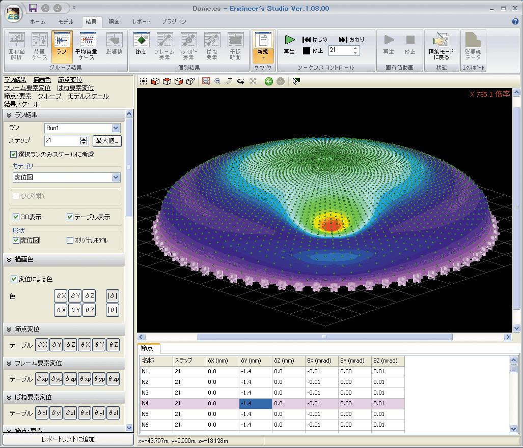
画面サンプル

▲メイン画面

▲描画設定

▲断面計算の入力画面
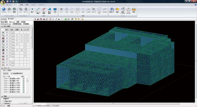
▲4万5千節点モデル

▲平板要素のひび割れ図
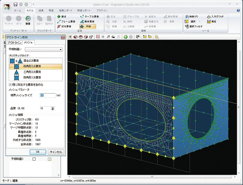
▲平板要素の自動メッシュ分割
▲平板要素のコンタ図

▲平板要素への面分布荷重載荷

▲平板要素に地盤ばねを自動生成

▲3次元コンタ図と
2次元切断面図

▲ケーブル要素の大変位解析

▲断面と連動したM-φ特性

▲緩衝装置用のばね特性

▲DXF/DWG形式
インポート/エクスポート

▲IFC形式エクスポート

▲RC非線形梁の偏差ひずみ
第2不変量(重み平均後)

▲照査でNG 部材の赤表示
Q&A(製品評価や導入の際に役立つQ&Aです)
- 何ができるのか?
-
3次元汎用解析ツールとして、2次元モデルから3次元立体フレームモデルまで作成可能です。
また、板要素を使用したFEMモデルも作成可能で、部材は線形要素から非線形要素まで、荷重も静的荷重から動的荷重まで対応可能となります。
- どのような計算に活用できる?
-
橋梁の静的解析や動的解析、河川構造物の耐震計算や水道施設の耐震診断、建築構造物の計算に活用できます。
また、他社にない機能としまして弊社のUC-1設計シリーズの橋台・橋脚・基礎・震度と連携して、保耐法の計算データから動的解析が可能なデータを自動生成可能です。
- 報告書として成果に活用可能?
-
もちろん可能です。ただし対象を桁橋や直線橋などに限定していませんので、出せるものは計算書レベルの出力となります。
Excelへのカット&ペーストが可能ですので報告書のひな形へ貼り付けながら結果をとりまとめることが可能です。
- どのような基準に対応している?
-
橋梁設計で使用される道路橋示方書のH14年版、H24年版、H29年版に対応しています。
また、断面照査ではコンクリート標準示方書の限界状態設計法にも対応しており、構造物の照査まで可能です。
- どのグレードを購入すればよい?
-
線形解析、静的解析メインの方はLite版、フレーム解析で非線形解析、動的解析まで必要な方はadvanced版、非線形のFEM解析が必要な方はultimate版をご購入下さい。
- 入力について不明な場合は?
-
製品ヘルプもしくはHPに電子マニュアルに製品詳細と操作法を準備しております。その他、定期的に開催される有償セミナーでは静的解析モデル、動的解析モデル、FEMモデルの3つのモデル化の講習が受講でき講師と質疑応答も可能です。また有償となりますが、計算モデルを作成する解析支援サービスもあり年間100件を超える実績がございます。
解析支援サービス:https://www.forum8.co.jp/product/ucwin/ES/ESkaiseki.htm>> サポートページ Engineer's Studio® Q&A集
