UC-win/Road UC-win/Roadサポートシステム UC-win/Road UC-win/Roadサポートシステム

・AVI-DivX:高解像度で動画ムービーをご覧になれます。※動画再生までに時間がかかる場合があります。
高解像度動画ムービー(AVI-DivXコーデック)をご覧いただくには、DivXコーデックが必要です。
DivX.com ダウンロード : http://download.divx.com/divx/DivX505Bundle.exe |
 |
グランプリ |
|
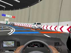
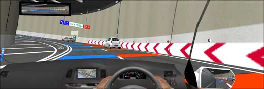
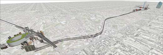
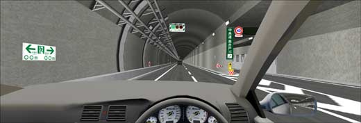
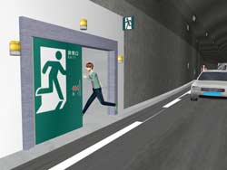
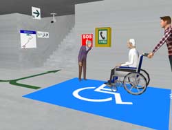
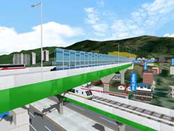
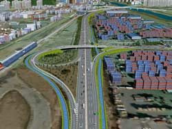
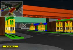
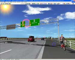
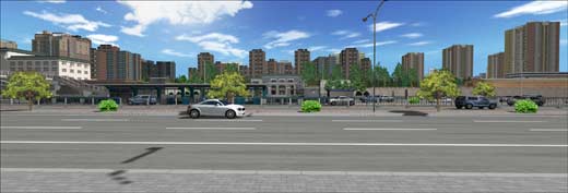
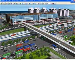
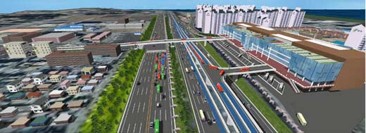
| 首都高速道路 大橋JCT 走行支援策 VRデータ |
 |
|
| 首都高速道路 株式会社 |
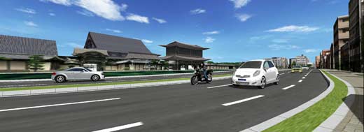
首都高速道路株式会社では、現在建設中の中央環状新宿線及び中央環状品川線と高速3号渋谷線を接続する大橋ジャンクションの走行支援策と交通安全対策における有効性を確認するために、ドライビングシミュレータによる実験を行っている。その実験において、UC-win/Roadドライブ・シミュレータを活用している。
| 大橋ジャンクションのコンテスト・グランプリ作品との実写比較ムービー ('10.04.21掲載) |
 |
大橋ジャンクション(首都高速道路、2010年 3月 28日開通)の実写ムービーと、コンテスト・グランプリ作品の比較ムービー
(※コンテスト・グランプリ作品は、大橋ジャンクション完成前に製作されたムービーです。) |
|
|
 |
 |
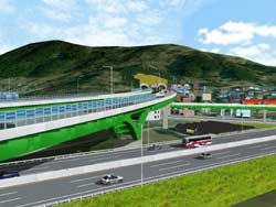
| ▲大橋JCT走行支援策VRデータ |
▲限られた用地に4枝交差 |
 |
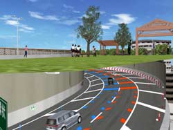 |
| ▲高低差70mに2回転のループ |
▲屋上は緑化公園を予定 |
 |
| ▲ドライブシミュレータによる走行支援策検討 |
 |
| ▲世界で2番目の長大トンネルとして計画 |
 |
| ▲新宿線-品川線のトンネルもモデリング |
 |
| ▲表示装置の位置最適化検討 |
 |
 |
| ▲避難経路説明でも活用 |
▲避難表示標識の最適化検討 |
|
|
|
 |
優秀賞 |
|
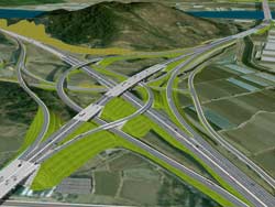
| 韓国南海高速道路設計変更VRシミュレーション |
|
|
| 韓国道路公社(韓国) |
施工中の韓国南海高速道路での住民との合意形成のためUC-win/Roadを利用した。最初の設計内容と現段階の設計内容が変り、住民からの反対があった。そこで、高速道路が住民へ及ぼす影響を高速道路と建物の距離をシミュレーションするなど様々なシミュレーションを行い、住民との同意と事業広報と関係機関での協議資料として利用した。
|
 |
 |
| ▲デドンJCT |
▲LRT計画による変更 |
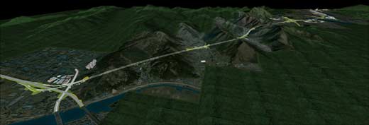 |
| ▲南海高速道路 ネンジョン-プサン区間 |
 |
| ▲トンネル避難連絡坑 |
 |
 |
| ▲交通渋滞の緩和 |
▲10m以上にも及ぶ遮音壁 |
 |
 |
| ▲貨物物流基地と下水処理場を結ぶ河川 |
▲住民説明会設計協議等で効果的に使用された |
|
|
|
 |
アイデア賞 |
|
| 鉄道桁架け替え工事シミュレーション |
|
|
| 株式会社 ノダエンジニアリング |
鉄道の増強に伴い、単線区間を複線化とするため高架橋の架け替えを行う。鉄道桁は、最終電車から始発電車の夜間に架け替え工事を終わらなくてはならなく、下部の道路に対しても工事の影響を最小に留める様に配慮しなければならない。スピーディーでなおかつ経済的な工法を計画し施工シミュレーションを行った。
|
 |
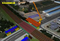 |
| ▲鉄道桁架け替え工事シミュレーション |
▲撤去桁つり上げ旋回 |
 |
| ▲仮置きヤードをはじめ周辺環境をモデル化 |
 |
 |
| ▲撤去桁横取り |
▲最終電車から始発までのスピーディーな施工 |
|
|
|
 |
エッセンス賞 |
|
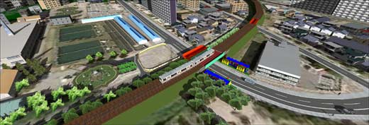
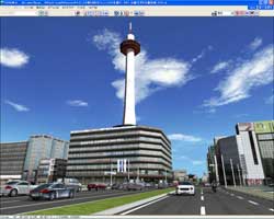
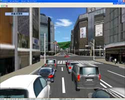
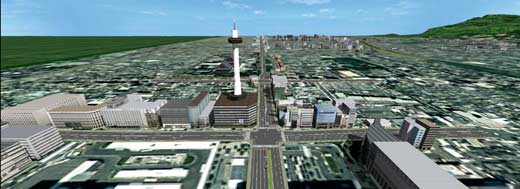
| 京都市街地交通シミュレーション |
|
|
| 京都大学大学院情報学研究科 |
人間の運転行動を再現する計算モデル構築のための運転データ収集を目的として、京都市街地の走行環境をUC-win/Roadドライブシミュレータ上に構築した。現実的な運転データ獲得のため、京都市街地を走行する感覚を与えるのに十分な品質の環境を構築した。本環境を用いて大量のデータを収集する被験者実験を計画中である。
|
 |
 |
| ▲京都市街地交通シミュレーション |
▲四条河原町付近の交通状態も再現 |
 |
| ▲人間の運転行動モデル構築のためのデータ収集を目標 |
 |
| ▲京都駅より京都大学付近までルートと周辺環境をモデリング |
 |
| ▲京都らしい周辺環境もモデリング |
|
|
|
 |
海外部門賞 |
|
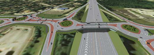
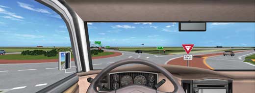
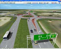
| US 41プロジェクトロータリーデザインにおけるVRデータ |
|
|
| Ourston Roundabout Engineering, Inc.(USA) |
ウィスコンシン州運輸省は、国道41号線を改築し拡張することを計画しています。この作品は、WisDOTがロータリーについてより詳しく学び、一般の人々がロータリーでの運転や歩行について学べるよう、Ourstonがロータリーを正しく運転するためのドライビングシミュレータ開発依頼を受けて作成したものです。
|
 |
 |
▲US41プロジェクト・ロータリーデザインにおける
VR |
▲ロータリーにおける
ドライバー教育シミュレーションを開発 |
 |
| ▲3連のロータリーインターチェンジの外観 |
 |
| ▲ウイウコンシン州運輸省は41号線に44のロータリーを計画 |
 |
 |
| ▲ロータリーは効率的な交通流を生む |
▲ロータリーの適切な運転方法を
伝えることが目的 |
|
|
|
 |
審査員特別賞 地域づくり賞 NPO地域づくり工房 傘木 宏夫 氏 |
|
| 水郷の里 日野市の用水路を活かした環境共生型区画整理の提案 |
|
|
| 法政大学 |
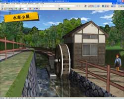
東京の有数の穀倉地帯であった日野市には、多摩川、浅川沿いに網の目のような用水路網が発達した。1960年代からの首都圏郊外部の急激な人口増加に対応するため日野市では積極的に区画整理事業を行い、現在では市域の5割が区画整理地域である。区画整理地域では用水路は統合され支線の多くは廃止されてしまった。用水路延長は昭和55年218km、平成3年177km、現在が130km程度と言われている。1995年には国土庁の「水の郷」の選定も受けたが現状では確実に田園風景は消え、用水路は減少している。そこで、日野市の用水を中心とした水辺空間を活かした環境共生型区画整理の在り方を提案するものである。
|
 |
 |
| ▲水郷の里日野市用水路環境共生方区画整理 |
▲用水路を利用した小水路発電 |
 |
| ▲集合住宅地区戸建て地区農園地区 |
 |
| ▲地産地消型の極小兼業農家 |
|
|
|
|
審査員特別賞 デザイン賞 大成建設株式会社 関 文夫 氏 |
|
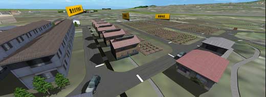
| 北京国棉グループ京棉第二工場VRプロジェクト |
|
|
| 北京水魔方数字科技 有限公司(中国) |
国棉グループは北京CBD東側にあり、正門からCCTV、中国国際貿易センター、華茂等北京の象徴的建物を一望できる。1950年代、旧ソ連のデザイナーが設計し建設が始まる。室内装飾などは当時の時代背景を反映している。UC-win/Roadを利用して、国棉第二工場の旧工場と、近年移転し文化創意産業園となる新工場の様子をVRで表現。
|
 |
 |
▲北京国棉グループ京棉第二工場
-事務室と国産扇風機 |
▲京棉第二工場全景 |
 |
| ▲正面と周辺建物-時代の流れから国棉文化創意産業園として生まれ変わる |
 |
 |
| ▲VRを用いて旧工場の資料保存 |
▲急速に使われた東屋など
VRで自由に閲覧できる |
|
|
|
|
審査員特別賞 芸術賞 八千代エンジニヤリング株式会社 喜多河 信介 氏 |
|
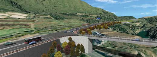
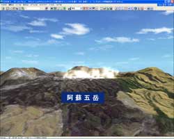
| "阿蘇の玄関にふさわしい道づくり"を目指して |
|
|
| 西鉄シー・イー・コンサルタント 株式会社 |
本VRは、阿蘇くじゅう国立公園を通過する国道(シーニック・バイウェイ)の4車線化データを作成したものである。本路線は、急峻地形であることに加え、鉄道併走により大型構造物が発生するため、走行シミュレーション(内部環境)のみではなく、外部環境へも配慮する必要があり、VRデータを活用して、景観検討及び渋滞緩和の提案を行った。
|
 |
 |
| ▲阿蘇の玄関にふさわしい道づくりを目指して |
▲シーニックバイウェイの4車線化モデル |
 |
| ▲渋滞緩和と景観保全を目指す |
 |
| ▲外部景観として阿蘇くじゅう国立公園をモデル化 |
 |
 |
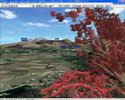
| ▲紅葉の季節も表現 |
▲阿蘇五岳 |
|
|
|
 |
ノミネート賞 |
|
| 道路モニタリングシステム |
|
|
| Temasek Polytechnic(シンガポール) |
道路モニタリングシステムは、リハビリ中のドライバーと評価を支援するための、バーチャル運転シミュレーターとしての機能を果たすシステムです。したがって、シミュレーターは患者の状態を評価するために、患者の健康状態と問題解決能力をテストすることができます。
|
 |
 |
| ▲道路モニタリングシステム |
▲脳卒中患者の手足の訓練シミュレータ |
 |
 |
| ▲信号制御や障害物の回避 |
▲ドライバーのバランスチェック |
 |
| ▲リハビリのシステムとして提案 |
|
|
|
|
ノミネート賞 |
|
| 韓国ジュクジョンサービスエリア乗換VRシミュレーション |
|
|
| GTSM Inc.(韓国) |
韓国ソウル地方国土管理局で管理するジュクジョンサービスエリアでの乗換計画をUC-
win/Roadを利用して、交通シミュレーションを行った。衛星都市へつながる道路の混雑を解決するため、バス専用道路の生成とロータリー生成などの三つの案をRoadを用いて意思決定の支援ツールとして利用した。
|
 |
 |
| ▲韓国ジュクジョンサービスエリア乗換VR |
▲交差点橋梁設置案 |
 |
 |
| ▲第2案高速バス市内バス分離案 |
▲第3案ロータリー設置案 |
 |
| ▲VRが事業決定に推進力を与えた結果となった |
|
|
|
|
ノミネート賞 |
|
| 歩道工事における歩行者流動VRシミュレーション |
|
|
| 上海筑紫建築工程設計諮詢 有限公司(中国) |
イギリスにある繁華街(約150m)で改修施工時における、歩行者の行動、流れをVRで表現している。群衆解析ソフトウエアの結果ファイルをデータ連係し、UC-win/Roadで直感的な表現を可能とした。改修後の再現と更なる安全性確保のため、全体的計画と歩行者流動のシミュレーションに活用されたデータである。
|
 |
 |
| ▲歩道工事における歩行者流動VRシミュレーション |
▲群集解析結果を
マイクロシミュレーションプレイヤに連携 |
 |
 |
| ▲歩道工事規制を実施した結果 |
▲店舗内群集流も表現 |
|
|
|